
Topo Maps+
GPS Maps for Hike, Hunt, Trail
Topo Maps+ for iPhone is a navigation app specially designed to be fully-featured travel app.
iPhone Screenshots
Related: Sygic GPS Navigation & Maps: Offline Maps, GPS & CarPlay Offline maps and more
‣‣ MAPS FOR EVERY ACTIVITY
‣Setup your map based on your planned activity
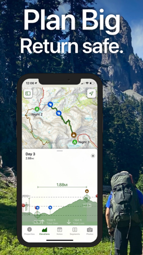
‣‣ PLANNING TOOLS
‣ Compare and Download maps for use offline.
‣ Combine overlays to customize your map view
‣ Smart route-building tools
‣ Waypoints
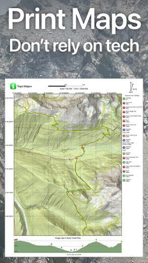
‣ Print, email or share custom maps and routes
‣ Public, Private, and Hunting land boundaries
‣ Parcel Information
‣ Create teams and live-share members’ last known location
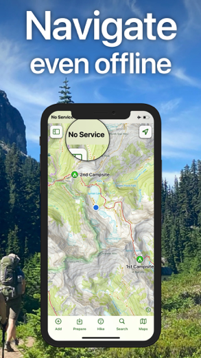
‣‣ ON-TRAIL TOOLS (Offline)
‣ View your current location
‣ All Maps and Overlays are downloadable
‣ Record your tracks - see where you’ve been
‣ Photo Waypoints - snap a pic and instantly shows on the map
‣ Progress on Trail - how much further on the trail
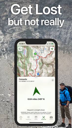
‣ Guide Me - to a waypoint
‣ Proximity Alerts - notify me when I’m close to a waypoint, trail, or region
‣ Line of Sight - what am I looking at?
‣ Downloaded elevation data for route-creation on the trail
‣‣ APPLE WATCH
‣ Integration with Apple HealthKit
‣Download maps directly to the watch
‣ Pan and zoom the map just like on the phone
‣ Drop a waypoint
‣ Record a track and see all of your stats
‣‣ CARPLAY
‣ Navigate to the trailhead
‣ Turn by Turn directions on USFS Roads
‣‣ NAVIGATIONAL MINDSET - helpful tips and tricks for keeping you safe in the backcountry!
‣‣ SUBSCRIPTION LEVELS:
FREE level: view low resolution maps, record your tracks, and limited features
Topo Maps+ Pro: high resolution maps, download maps, planning & on-trail tools, driving mode, import geospatial PDFs and TIFFS, MapBox Satellite map, US public and private land overlays, parcel and ownership contact info, game management units.
‣‣ CLOUD
Sync your routes, trips, subscriptions, and waypoints between all of your iOS and Mac devices.
SUBSCRIPTION PAYMENT INFORMATION
Topo Maps+ subscriptions will be charged to your Apple ID account at the confirmation of purchase and/or completion of free trial. Subscription automatically renews unless it is canceled at least 24 hours before the end of the free trial or current period. Your account will be charged for renewal within 24 hours prior to the end of the current period. You can manage and cancel your subscriptions by going to your account settings on the App Store after purchase.
Privacy Policy: https://topomaps.co/info/privacy
Terms of Service: https://topomaps.co/info/tos
Continued use of GPS running in the background can dramatically decrease battery life.
Related: GOHUNT / GPS Hunting Map: Offline GPS Hunting Maps
Topo Maps+ Walkthrough video reviews 1. Using Topo Maps Offline
2. Topo Maps
Is it good?
Glacier Peak Studios LLC has put efforts and engineered a sophisticated hike app. What makes it successful? It is very easy to use for such a solid navigation app with built-in hunt features. Well, as a top-performing app with an overall rating of 4.76 I can only add what people who have tried it are saying.
I have been using this app for almost two years now and have used it in the USA from coast to coast Hawaii and even in Guam.
It has never failed to get me information I need to make it to the trailhead and into the backcountry.
There is sometimes a little learning curve to pick the right map city, suburbs or backcountry, but once I’ve made a decision I have never Ben disappointed.
I have used this app on Three of New Zealand’s Great walks and several day hikes just inside and out of Aukland.
And just recently used it just for grins at the Great Wall outside of Beijing, don’t need a map to follow the Great Wall. My only issue there was lack of gps coverage even with a bad elf plugged into my iPhone 7 Plus.
Keep playing with the map because every time I do, I seem to find something else that's new.
I’m a tried and true paper map hiker but love this app for the holes in paper map coverage or route changes in my wanderings.
Can’t wait to try out the new US Natural Map.
One of those really rare apps where function, interface and support are all near-perfect. Even when I’m in Thailand the maps are more useful than Google or Apple for outdoor navigation. In the US, the detail includes hi-res satellite images and everything USGS offers.
You can plan a route to avoid whatever features you want to, see an elevation profile, and zoom in on satellite imagery close enough to see if roads and trails look like fun.
When you’re under way, you get a warning when you’re off track, an easy way to take a bearing on nearby topographic features, and a very detailed log. Add photos whenever. The Apple Watch app works like a charm, too: no need to have your phone with you.
Get home and export your track to Google Earth, e-mail it to your mother, whatever.
Yes, you have to pay — but none of the other gear you need is free, and very little of it is as good.
Download Topo Maps+ free for iPhone and iPad
In order to download IPA files follow these steps.
Step 1: Download the Apple Configurator 2 app to your Mac.
Note that you will need to have macOS 10.15.6 installed.
Step 2: Log in to Your Apple Account.
Now you have to connect Your iPhone to your Mac via USB cable and select the destination folder.
Step 3: Download the Topo Maps+ IPA File.
Now you can access the desired IPA file in the destination folder.
Download from the App Store
Is it good?
Glacier Peak Studios LLC has put efforts and engineered a sophisticated hike app. What makes it successful? It is very easy to use for such a solid navigation app with built-in hunt features. Well, as a top-performing app with an overall rating of 4.76 I can only add what people who have tried it are saying.
I have been using this app for almost two years now and have used it in the USA from coast to coast Hawaii and even in Guam. It has never failed to get me information I need to make it to the trailhead and into the backcountry. There is sometimes a little learning curve to pick the right map city, suburbs or backcountry, but once I’ve made a decision I have never Ben disappointed. I have used this app on Three of New Zealand’s Great walks and several day hikes just inside and out of Aukland. And just recently used it just for grins at the Great Wall outside of Beijing, don’t need a map to follow the Great Wall. My only issue there was lack of gps coverage even with a bad elf plugged into my iPhone 7 Plus. Keep playing with the map because every time I do, I seem to find something else that's new. I’m a tried and true paper map hiker but love this app for the holes in paper map coverage or route changes in my wanderings. Can’t wait to try out the new US Natural Map.
One of those really rare apps where function, interface and support are all near-perfect. Even when I’m in Thailand the maps are more useful than Google or Apple for outdoor navigation. In the US, the detail includes hi-res satellite images and everything USGS offers. You can plan a route to avoid whatever features you want to, see an elevation profile, and zoom in on satellite imagery close enough to see if roads and trails look like fun. When you’re under way, you get a warning when you’re off track, an easy way to take a bearing on nearby topographic features, and a very detailed log. Add photos whenever. The Apple Watch app works like a charm, too: no need to have your phone with you. Get home and export your track to Google Earth, e-mail it to your mother, whatever. Yes, you have to pay — but none of the other gear you need is free, and very little of it is as good.
Download Topo Maps+ free for iPhone and iPad
In order to download IPA files follow these steps.
Step 1: Download the Apple Configurator 2 app to your Mac.
Note that you will need to have macOS 10.15.6 installed.
Step 2: Log in to Your Apple Account.
Now you have to connect Your iPhone to your Mac via USB cable and select the destination folder.
Step 3: Download the Topo Maps+ IPA File.
Now you can access the desired IPA file in the destination folder.
Download from the App Store