

onX Hunt for iPhone - APP DOWNLOAD
GPS Hunting Maps Find Property & Land to Hunt
FREE TRIAL: onX Hunt is a navigation iPhone app specially designed to be fully-featured travel app.
iPhone Screenshots


New features including Aerial imagery, In-Dash Navigation with Apple CarPlay, and Trail Camera Integration ensure onX is your go-to tool for this hunting season and beyond. Our new Two-State Premium Membership allows you to have full access to all onX features in two states, ideal for hunters who cross state lines.
▶ FREE TRIAL:
While the onX Hunt App and many of its features are free, you’ll start a free Premium State Membership trial when you install the App. This allows you to try a full-featured Premium State Membership for seven days.
▶ FREE HUNTING APP FEATURES:
• NO ADS
• Satellite Maps and 24K Topographical Maps with GPS Navigation
• Local weather conditions, forecasts, wind speeds, and wind direction
• Aerial / Topo Hybrid overlay to see contours with satellite imagery
• Hunting Zones, Areas, or Game Management Units (GMU) for game species in all 50 states
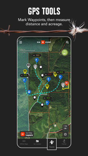
• New Compass Mode with Rangefinder: find orientation and distance from map points
• Mark Waypoints with custom icons for camps, vehicles, and more
• Measure distances with the Line Tool
• Measure food plot acreage with the Shape Tool
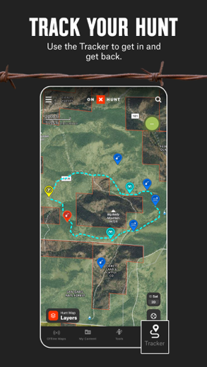
• Track the distance, coordinates, duration, and speed of your hunt with Tracker
▶ OFFLINE GPS FUNCTIONALITY:
The onX Hunt App turns your phone into an outdoor handheld GPS navigator using the built-in GPS to display your location on the map. Cellular coverage is NOT needed as tile-saving technology allows you to save basemaps and layers for offline navigation.
▶ DESKTOP MAPS: Memberships also include access to our online Web Hunting Map (www.onxmaps.com/web).
• Scout from the comfort of your home
• Sync markups and tracks between devices
• Print unlimited free maps
▶ PREMIUM SINGLE-STATE MEMBERSHIP:
With a Premium State Membership, you gain access to our proprietary hunting GPS maps developed by our GIS team. This membership costs $29.99/year. Get all the great features of the free onX Hunt App PLUS the additional benefits of:
• Public land like Forest Service, Bureau of Land Management (BLM maps), Wildlife Management Areas, county and state land hunting maps, Timber Lands, and more
• 3D maps on phone and desktop
• Optimal Wind and Wind Calendar for stand locations and hunt planning
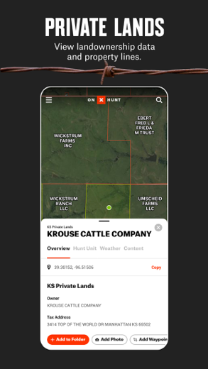
• Landowner names with property line maps and land boundaries finder in available counties (U.S. only)
• Search by landowner name or hunting property landowner boundaries
• Save private or public hunting land maps for offline use
• GMU or Hunting Units for multiple species
• Possible Access Lands, Walk-In Areas, Block Management Areas, and private lands open to the public
• The largest database of nationwide roads and trails ever built
* Private land ownership maps may not be available for all counties (U.S. only)
▶ PREMIUM TWO-STATE MEMBERSHIP:
With a Premium Two-State Membership, you get all the benefits of our Premium Single-State Membership, but for two states. A Premium Two-State Membership costs $44.99/year and gets you all the great features of the free onX Hunt App PLUS the additional benefits listed above.
▶ ELITE NATIONWIDE MEMBERSHIP:
The best tool for the best hunters. With an Elite Membership, you get a complete, purpose-built solution for dedicated hunters and the game they pursue, including:
• Proprietary maps for all 50 states
• Advanced Tools: TerrainX 3D, Recent Imagery, Route Builder
• Elite-exclusive pro deals and expert resources
Easily scout, plan, and master your hunts for any species in any state for one membership price. Available for $99.99/year or $14.99/month.
▶ TERMS OF USE:
https://www.onxmaps.com/tou
▶ FEEDBACK:
Have a problem or want to request new features? Contact us at [email protected]
Related: Sygic GPS Navigation & Maps: Offline Maps, GPS & CarPlay Offline maps and more
onX Hunt Walkthrough video reviews 1. onX Hunt 101: Master the App
2. How To Navigate and Track Your Location While Hunting with onX Hunt
Download onX Hunt free for iPhone and iPad
In order to download IPA files follow these steps.
Step 1: Download the Apple Configurator 2 app to your Mac.
Note that you will need to have macOS 10.15.6 installed.
Step 2: Log in to Your Apple Account.
Now you have to connect Your iPhone to your Mac via USB cable and select the destination folder.
Step 3: Download the onX Hunt IPA File.
Now you can access the desired IPA file in the destination folder.
Download from the App Store