
National Hurricane Center Data
NHC Hurricane Tracker App
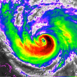
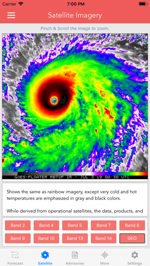
GOES Satellite Imagery Animations
National Hurricane Center Data pour iPhone est un météo application spécialement conçu pour être complet national application.
iPhone Captures d'écran


MAIN FEATURES INCLUDE:
+ GOES Satellite Imagery Animations
+ National Hurricane Center Products
+ National Weather Service Alerts
+ Weather Prediction Center Graphics
+ Tropical Weather Push Notifications
+ Satellite Imagery Home Screen Widget
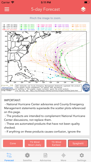
+ Spaghetti Models
GRAPHICAL PRODUCTS INCLUDE:
Forecast Graphics
- Spaghetti Models
- 7-Day Tropical Weather Outlook
- 3-Day Excessive Rainfall Outlook
- 7-Day Quantitative Precipitation Forecast
Storm Specific Graphics
- Key Messages
- Cone Track Forecast
- Tropical Storm Wind (Most Likely)
- Tropical Storm Wind (Earliest)
- Hurricane Wind Probability
- Surface Wind Field
- Surface Wind Analysis
- Wind / Track History
- Rainfall Forecast
- Flash Flood Risk
Local Storm Threat Graphics
- Flooding Rain Threat
- Wind Threat
- Surge Threat
- Tornado Threat
- Rainfall Totals
- Wind Warnings
Note: Local threat graphics are typically not available until shortly before storm landfall.
TEXT PRODUCTS INCLUDE:
- Tropical Weather Outlook
- Forecast Advisories
- Public Advisories
- Forecast Office Discussion
- Local Statement (HLS)
- Local Warnings (TCV)
- Tropical Discussion
- Wind Analysis
WEATHER MAP OVERLAYS INCLUDE:
- Hurricane Track & Intensity
- Potential Storm Surge Flooding
- NASA Sea Surface Temperature
- NOAA Weather Radar
GOES SATELLITE IMAGERY INCLUDES:
Fifteen (15) Satellite Imagery Filters
- Visible (Band 2)
- Near IR (Bands 4 & 5)
- Infrared (Bands 7, 8, 9, 10, 13, 14 & 16)
- Nighttime Microphysics
- Day Cloud Phase
- True Color
- Air Mass
- Sandwich
APPLE WATCH APP INCLUDES:
- View wind speed & intensity updates every 30 minutes
- View the latest satellite imagery
- Choose from a variety of Watch Complications
-- PRO SUBSCRIPTION FEATURES --
Full Screen, High Resolution Satellite Imagery:
- Latest Image
- Animated Loop
- Mesoscale: Near Real-time Imagery
- Geostationary Lightning Mapper (GLM)
Mesoscale imagery typically has 1-minute temporal resolution, but is not always available for each storm.
16-day Weather Forecast Models:
- Global Forecast System (GFS)
- Global Ensemble Forecast System (GEFS)
- North American Ensemble (NAEFS)
Weather Simulation Forecast Models:
- Hi-Res Rapid Refresh (HRRR)
- Hi-Res Ensemble Forecast (HREF)
- North American Mesoscale (NAM)
- Hi-Res North American Mesoscale
(NAM-HIRES)
- High Resolution Window
(HRW-FV3, HRW-ARW, HRW-ARW2)
- WaveWatch III (WW3)
- European Centre for Medium-Range Weather
(ECMWF)
HMON & HWRF Hurricane Forecast Models
Experimental Forecast Animations:
- Simulated Radar 2km
- Surface Pressure, Wind
- 200mb Temp, Ht, Wind
- 700mb RH, Ht, Wind
- 850mb Vort, Wind, Thick
Model Analysis & Guidance Animations:
- 6h Total Precipitation
- 10m Wind
- 200mb Vort, Wind, Ht
- 500mb Relative Humidity
- 700mb Vort, Wind, Ht
- 850mb Vort, Wind, Ht
Static Forecast Products
- Track*
- Intensity*
- Pressure*
- Rain
- Wind
* Track, Intensity and Pressure graphics include spaghetti plots when available. Models included in spaghetti graphics include: HWRF, HMON, CTCX, AVNO, SHF5 & OFCL.
NCEP / EMC Cyclogenesis Tracking Products
- 16-day Storm Forecast Tracks
- 21-day Global Tropics Hazards Outlook
- 35-day Probability of Formation
CIMSS Tropical Cyclone Products
- Wind Vorticity & Shear Analysis
- Steering Layer Analysis
- Morphed Integrated Microwave Imagery
- Advanced Dvorak Technique (ADTV9.0)
ADT Includes imagery, wind radii estimates & trends
Interactive Hurricane Tracker Map
- Track & Intensity Forecast
- Preliminary Best Track Analysis
TERMS & CONDITIONS
https://lwbrandsllc.com/hurricane-app-terms-conditions/
--
In total, there are now over 100+ hurricane / weather tracking products to help you stay informed during hurricane season.
National Hurricane Center Data Procédure pas à pas critiques vidéo 1. Hurricane Season Begins in The Villages Florida 2023 and I get ready for Storm Chasing
2. Check Out This NEW Weather Info! Floods, Lightning, and Maybe WATERSPOUTS Coming Soon!
Télécharger National Hurricane Center Data gratuit pour iPhone et iPad
Pour télécharger les fichiers IPA, suivez ces étapes.
Étape 1 : Téléchargez l'application Apple Configurator 2 sur votre Mac.
Notez que vous devrez avoir installé macOS 10.15.6.
Étape 2 : Connectez-vous à votre compte Apple.
Vous devez maintenant connecter votre iPhone à votre Mac via un câble USB et sélectionner le dossier de destination.
Étape 3 : Téléchargez le fichier National Hurricane Center Data Fichier IPA.
Vous pouvez maintenant accéder au fichier IPA souhaité dans le dossier de destination.
Download from the App Store