
Aqua Map
Mobile Chartplotter Boating, sailing & fishing GPS
Optimised for both iPhone and iPad with multi-screen mode
Aqua Map iPhone의 경우 입니다 내비게이션 앱 모든 기능을 갖추도록 특별히 설계된 여행 앱.
iPhone 스크린샷


Get the latest charts you can use offline, weather, tides and POIs from ActiveCaptain and Waterway Guide.
Connect AIS and your boat GPS and instruments data via WiFi connection. Plan routes, record your tracks, find new friends on the water and share your data across the Live Sharing community.
THE MOST ADVANCED MARINE NAVIGATION APP
• Optimised for both iPhone and iPad with multi-screen mode
• Vector and raster nautical charts for offline use, updated regularly
• Satellite image
• Routes/Tracks navigation with real-time information on bridges, hazards, and best fuel prices
• Manual route planning
• Basic anchor alarm and AnchorLink with mirroring and email/telegram notifications
• Marine Forecasts for wind, waves, currents and worldwide weather information
• 1800+ Weather buoys to get real time sea info
• Tide & Current predictions and simulations
• USACE surveys and USCG List of lights
• 14000+ vector lake maps
• Easy sharing and uploading of tracks, markers and routes
• Live Sharing-Aqua Map community to find new friends on the water
• ActiveCaptain & Waterway Guide community integration
• Real time display of NMEA instruments (depth sounder, wind sensor, compass, GPS)
• AIS target display with automatic collision detection
• Powerful search with advanced settings
• Light/Dark display
• Optimised battery usage
► NAUTICAL CHARTS
Official NOAA charts complete with depth contours, navigation markers, buoys, lights and other chart features. You can download the maps at home on all your devices and use them on the boat offline (no internet connection required).
► ROUTES and WAYPOINTS
Plan your trip, insert and edit waypoints. Navigate your route and your track, monitor distance, time (ETA), course and heading to next waypoint or your final destination.
► ANCHOR ALARM
Set the anchor position and drift radius and monitor in real time. If the GPS position is outside the defined range, an acoustic alarm is sounded and a visual alarm is displayed. Low battery and bad GPS reception alarms are also available.
► TIDES & CURRENTS
You can calculate the prediction for more than 7500 stations in US, Canada, Bahamas & Australia. See the T&C trend on the map and simulate any future date.
► LOADING and SHARING
You can share your favorite's markers on Facebook or send an email with your last daily track. Not only, you can also load any KML, KMZ, GPX found in internet or received from your friends.
► COMMUNITIES
Join “Live Sharing” and become part of Aqua Map community: find new friend on the water, chat and send your data to anyone without leaving the app.
Access tens of thousands of points of interests and reviews all over the world from ActiveCaptain and Waterway Guide communities.
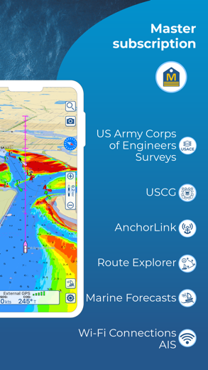
► AQUA MAP MASTER
Transform your device into a chartplotter:
• Most updated USACE surveys and USCG List of Lights
• Marine forecasts (wind, waves, currents and weather)
• AnchorLink with mirroring and telegram/email notifications
• Connect NMEA (and SignalK) devices through WiFi and use instrument and AIS data all across the app (navigation and anchor alarm)
• Display AIS targets on the chart with automatic collision detection
• Route Explorer with real-time information on bridges, hazards, and best fuel prices
(Note: This subscription includes extra features but does not include cartography; it must therefore be paired with a cartography subscription)
► TYPE OF PURCHASES
Unlimited: download and update forever (available only for some subscription)
Subscription: one year auto-renewable subscription. The payment will be made through your (Apple ID) account. The subscription will renew automatically unless cancelled at least 24 hours before the expiration. The user can manage their subscription and turn off auto-renewal in the Apple ID Account Settings section after purchase.
Terms of Service: https://www.aquamap.app/terms-and-conditions
Privacy Policy: https://www.aquamap.app/privacy-policy
관련된: Sygic GPS Navigation & Maps: Offline Maps, GPS & CarPlay Offline maps and more
Aqua Map 연습 비디오 리뷰 1. How to plan a route in Aqua Map
2. Webinar #1 - Aqua Map Overview
다운로드 Aqua Map iPhone 및 iPad용 무료
IPA 파일을 다운로드하려면 다음 단계를 따르세요.
1단계: Apple Configurator 2 앱을 Mac에 다운로드합니다.
macOS 10.15.6이 설치되어 있어야 합니다.
2단계: Apple 계정에 로그인합니다.
이제 USB 케이블을 통해 iPhone을 Mac에 연결하고 대상 폴더를 선택해야 합니다.
3단계: Aqua Map IPA 파일.
이제 대상 폴더에서 원하는 IPA 파일에 액세스할 수 있습니다.
Download from the App Store
다운로드 Aqua Map iPhone 및 iPad용 무료
IPA 파일을 다운로드하려면 다음 단계를 따르세요.
1단계: Apple Configurator 2 앱을 Mac에 다운로드합니다.
macOS 10.15.6이 설치되어 있어야 합니다.
2단계: Apple 계정에 로그인합니다.
이제 USB 케이블을 통해 iPhone을 Mac에 연결하고 대상 폴더를 선택해야 합니다.
3단계: Aqua Map IPA 파일.
이제 대상 폴더에서 원하는 IPA 파일에 액세스할 수 있습니다.
Download from the App Store